easyclimate_map.map.map_zh_CN
zh_CN Map
Functions
|
Get China national boundary data in either line or polygon format. |
|
Get China provincial-level administrative boundary data. |
|
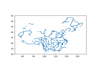
Get major river systems in China (Level 1 rivers). |
|
Get tertiary river systems in China (Level 3 rivers). |
|
Get first-level administrative center locations in China. |
|
Get second-level administrative center locations in China. |
Module Contents
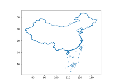
- easyclimate_map.map.map_zh_CN.get_zh_CN_nation(type: Literal['line', 'polygon'] = 'line') geopandas.GeoDataFrame
Get China national boundary data in either line or polygon format.
This function returns geographic boundary data for China’s national borders. The data includes mainland China’s coastline and land borders with neighboring countries.
Parameters
- type{“line”, “polygon”}, default “line”
Geometry type to return: - “line”: Boundary lines (coastlines and land borders) - “polygon”: Polygonal representation of China’s territory
Returns
- geopandas.GeoDataFrame
GeoDataFrame containing China’s national boundary features. The CRS is typically EPSG:4326 (WGS84).
Notes
Data source: Standard Chinese cartographic data
Encoding: GB2312 (Chinese character encoding)
Includes territories claimed by China (e.g., Taiwan, South China Sea islands)
Example(s) related to the function
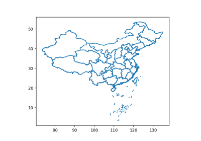
- easyclimate_map.map.map_zh_CN.get_zh_CN_provinces(type: Literal['line', 'polygon'] = 'line') geopandas.GeoDataFrame
Get China provincial-level administrative boundary data.
Returns boundary data for all provincial-level divisions in China, including: - 23 provinces - 5 autonomous regions - 4 municipalities - 2 special administrative regions (Hong Kong, Macau)
Parameters
- type{“line”, “polygon”}, default “line”
Geometry type to return: - “line”: Provincial boundary lines - “polygon”: Polygonal representation of provincial territories
Returns
- geopandas.GeoDataFrame
GeoDataFrame with provincial boundary features, including attributes for province names and administrative codes.
Notes
Data follows Chinese administrative divisions as of the data source date
Taiwan is included as a province of China according to the data source
South China Sea islands are typically included in Hainan province
Example(s) related to the function
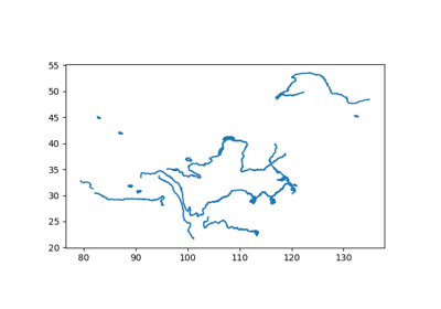
- easyclimate_map.map.map_zh_CN.get_zh_CN_river1(type: Literal['line', 'polygon'] = 'line') geopandas.GeoDataFrame
Get major river systems in China (Level 1 rivers).
Returns geographic data for China’s primary river systems, including: - Major rivers (Yangtze, Yellow River, Pearl River, etc.) - Large lakes and reservoirs - Important water bodies
Parameters
- type{“line”, “polygon”}, default “line”
Geometry type to return: - “line”: River centerlines and watercourse boundaries - “polygon”: Water body areas (lakes, reservoirs, wide rivers)
Returns
- geopandas.GeoDataFrame
GeoDataFrame containing major river and water body features. May include attributes for river names and hydrological classifications.
Example(s) related to the function
- easyclimate_map.map.map_zh_CN.get_zh_CN_river3(type: Literal['line', 'polygon'] = 'line') geopandas.GeoDataFrame
Get tertiary river systems in China (Level 3 rivers).
Returns geographic data for smaller rivers and streams, including: - Tributaries and smaller watercourses - Minor lakes and ponds - Drainage networks
Parameters
- type{“line”, “polygon”}, default “line”
Geometry type to return: - “line”: Stream centerlines and minor watercourses - “polygon”: Small water body areas
Returns
- geopandas.GeoDataFrame
GeoDataFrame containing tertiary river and water body features. Provides more detailed hydrological data than Level 1 rivers.
Notes
This dataset offers higher spatial resolution than Level 1 rivers
May not include complete coverage for all regions
Example(s) related to the function
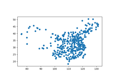
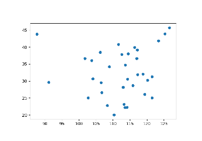
- easyclimate_map.map.map_zh_CN.get_zh_CN_1st_administration() geopandas.GeoDataFrame
Get first-level administrative center locations in China.
Returns point locations for administrative centers at the provincial level, including: - Provincial capitals - Municipal government seats - Autonomous region capitals
Returns
- geopandas.GeoDataFrame
GeoDataFrame with point features representing administrative centers. Includes attributes for center names, administrative levels, and codes.
Notes
Typically includes 34 administrative centers (31 provincial-level + 3 special)
Coordinates represent government seat locations
Example(s) related to the function
- easyclimate_map.map.map_zh_CN.get_zh_CN_2nd_administration() geopandas.GeoDataFrame
Get second-level administrative center locations in China.
Returns point locations for administrative centers at the prefecture level, including: - Prefecture-level city governments - Autonomous prefecture capitals - League administrative centers
Returns
- geopandas.GeoDataFrame
GeoDataFrame with point features representing prefecture-level administrative centers. Includes detailed location attributes.
Notes
Covers approximately 333 prefecture-level divisions in China
Includes both urban and rural administrative centers
Example(s) related to the function